What is Positioning, Navigation and Timing (PNT)?
PNT is a combination of three distinct, constituent capabilities:
- Positioning, the ability to accurately and precisely determine one's location and orientation two-dimensionally (or three-dimensionally when required) referenced to a standard geodetic system (such as World Geodetic System 1984, or WGS84);
- Navigation, the ability to determine current and desired position (relative or absolute) and apply corrections to course, orientation, and speed to attain a desired position anywhere around the world, from sub-surface to surface and from surface to space; and
- Timing, the ability to acquire and maintain accurate and precise time from a standard (Coordinated Universal Time, or UTC), anywhere in the world and within user-defined timeliness parameters. Timing also includes time transfer.
When PNT is used in combination with map data and other information (weather or traffic data, for instance) the result is the most popular and recognizable service--the modern navigation system better known as the Global Positioning System (GPS).
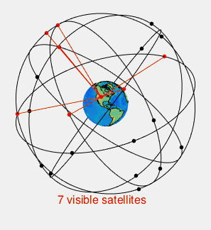
Image created by Paulsava/CC 4.0
While PNT encompasses so much more than navigational functions, GPS is a major component. There are currently over two billion GPS users nationwide. GPS.gov, the nation’s official website on GPS defines it as:
“A U.S.-owned utility that provides users with positioning, navigation, and timing (PNT) services. This system consists of three segments: the space segment, the control segment, and the user segment. The U.S. Air Force develops, maintains, and operates the space and control segments.”
The space segment of GPS refers to a system of 24 satellites circling the Earth. The control segment refers to the monitoring stations, set up worldwide that monitor and maintain the satellites. The user segment refers to the countless military, governmental, commercial and other entities – including private citizens – that rely on the GPS system for countless