National Address Database
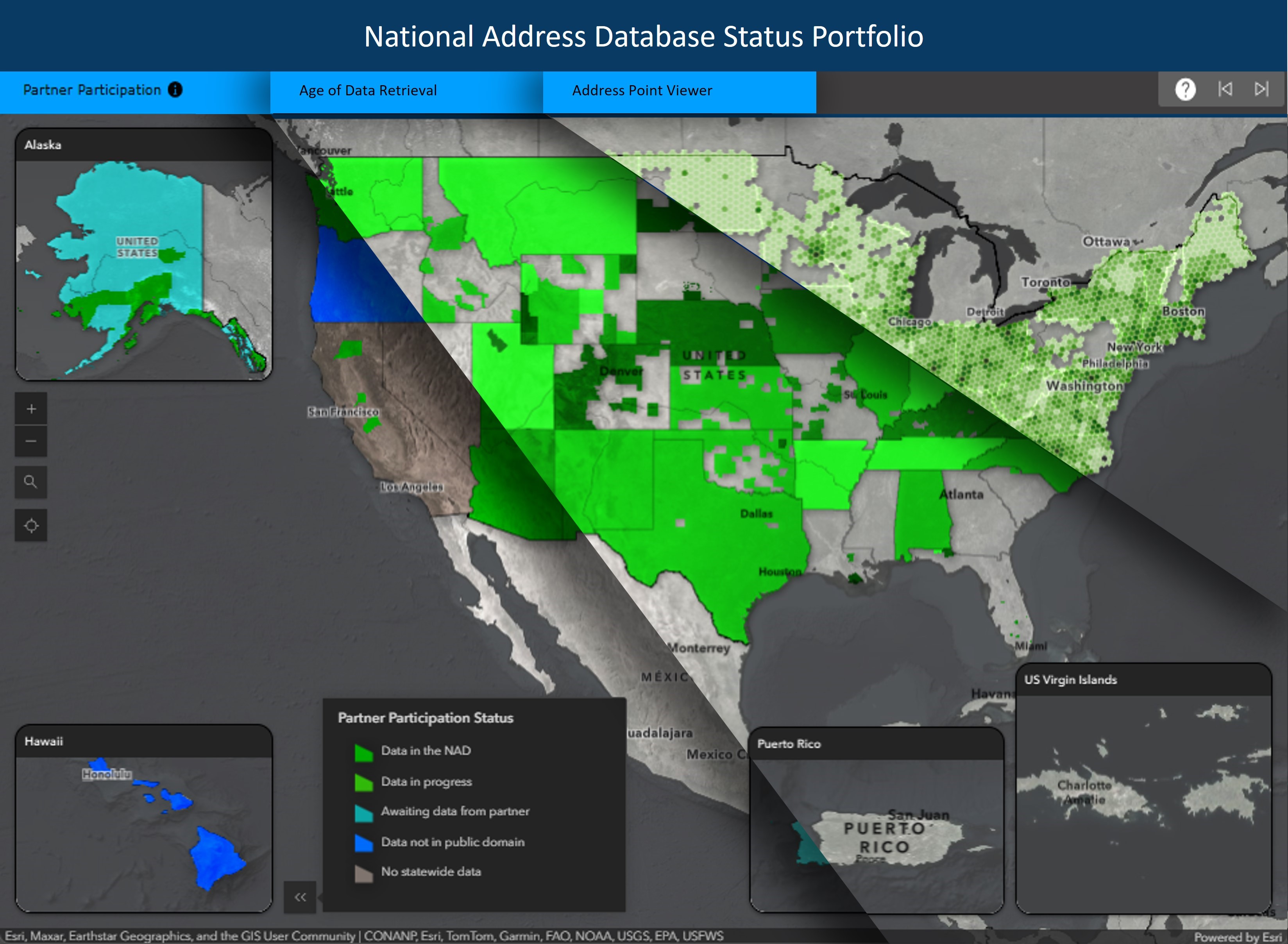
The U.S. Department of Transportation (USDOT) and its partners from all levels of government recognize the need for a National Address Database (NAD). Accurate and up-to-date addresses are critical to transportation safety and are a vital part of Next Generation 9-1-1. They are also essential for a broad range of government services, including mail delivery, permitting, and school siting. To meet this need, USDOT partners with address programs from state, local, and tribal governments to compile their authoritative data into the NAD.
To learn more about addresses and the National Address Database please visit this StoryMap.
Release 14 of the NAD, containing 75.9 million records, is now available for download from the link at the top left of this page.
The NAD has been working from the same schema since 2017. That schema was loosely based on the National Emergency Number Association (NENA) Next Generation 9-1-1 address standard and the Federal Geographic Data Committee (FGDC) Address Data Content Standard. Since then, the Address Content Subgroup of the Address Subcommittee of the FGDC has compiled content requirements for the NAD, and the NAD is in the process of migrating and transitioning to a new schema to align with these content requirements. Guidance for the latest schema will be provided here in the near future.
If you represent a state or local government and would like to include your address points in the NAD, please contact us at nad@dot.gov.

View detailed information on participation by state below the maps.

View detailed information on processing status by county below the maps.

View detailed information on age of data submission by State below the maps.
USDOT National Address Database (NAD) Map, Partner Participation by State (as of July 2023)
The color-coded key is described as follows:
Thirty-Six (36) Dark Green states have provided address data including: Alaska, Arizona, Arkansas, California, Colorado, Connecticut, Delaware, District of Columbia, Florida, Illinois, Indiana, Iowa, Kansas, Kentucky, Maine, Maryland, Massachusetts, Montana, Nebraska, New Jersey, New Mexico, New York, North Carolina, North Dakota, Ohio, Oklahoma, Pennsylvania, Rhode Island, Tennessee, Texas, Utah, Vermont, Virginia, Washington, Wisconsin, and Wyoming.
Three (3) Yellow states have not yet submitted data to be processed including: Mississippi, Puerto Rico, and West Virginia.
Six (6) Light purple states do not have data to provide including: Alabama, Georgia, Idaho, Louisiana, Missouri, and Nevada.
Seven (7) Dark purple states may have data that is not in the public domain including: Hawaii, Michigan, Minnesota, New Hampshire, Oregon, South Carolina, and South Dakota.
Hashed lines over Six (6) states represent Tribal or local-level participation rather than state-wide participation including: Alabama, Louisiana, Minnesota, Missouri, South Carolina, and South Dakota.
Note that not all states have 100% coverage.
USDOT National Address Database (NAD) Map, Processing Status by County (as of July 2023)
The map includes a color-coded key that identifies the NAD status level by county.
The color-coded key is described as follows:
Dark Green color indicates submitted address data has been processed for the following Nineteen (19) whole states: Arizona, Connecticut, Delaware, District of Columbia, Illinois, Indiana, Maine, Massachusetts, Montana, New Jersey, New Mexico, New York, North Carolina, Ohio, Rhode Island, Tennessee, Utah, Vermont, and Virginia; and Twenty-Three (23) partial states including parts of: Alabama, Alaska, Arkansas, California, Colorado, Florida, Iowa, Kansas, Kentucky, Louisiana, Maryland, Minnesota, Missouri, Nebraska, North Dakota, Oklahoma, Pennsylvania, South Carolina, South Dakota, Texas, Washington, Wisconsin, and Wyoming.
Light Yellow color indicates data has not been provided for processing yet and remains 'In Queue' status for the following Three (3) whole states: Mississippi, Puerto Rico, and West Virginia; and Nine (9) partial states including parts of: Alaska, California, Florida, Kentucky, Nebraska, Oklahoma, Pennsylvania, Texas, and Washington.
Light Purple color indicates data does not exist or is not part of the statewide program for the following Three (3) whole states: Georgia, Idaho, and Nevada; and Eight (8) partial states including parts of: Alabama, Arkansas, Colorado, Iowa, Louisiana, Missouri, Wisconsin, and Wyoming.
Dark Purple color indicates the data may not be in the public domain for the following Four (4) whole states: Hawaii, Michigan, New Hampshire, and Oregon; and Seven (7) partial states including parts of: Colorado, Kansas, Maryland, Minnesota, North Dakota, South Carolina, and South Dakota.
Note that not all states have 100% coverage.
USDOT National Address Database (NAD) Map, Age of Data Submission by State (as of July 2023)
The map includes a color-coded key that identifies the NAD age of data submission by state.
The color-coded key is described as follows:
Dark Green color indicates the newest data is less than Six (6) months old for the following Thirteen (13) states: Alabama, Arizona, Illinois, Indiana, Kentucky, Minnesota, Montana, Nebraska, New York, North Carolina, Ohio, Washington, and Wyoming.
Light Green color indicates the newest data is less than One (1) year old for the following Twenty-Two (22) states: Alaska, Arkansas, California, Colorado, Connecticut, Delaware, District of Columbia, Florida, Kansas, Maine, Maryland, Massachusetts, New Mexico, Oklahoma, Pennsylvania, South Carolina, South Dakota, Tennessee, Texas, Utah, Vermont, and Virginia.
Yellow color indicates the newest data is less than Two (2) years old for the following Six (6) states: Iowa, Louisiana, Missouri, New Jersey, North Dakota, and Rhode Island.
Red color indicates the newest data is at least Three (3) years old for the state of: Wisconsin.
Dark Grey color indicates data is not currently provided for the following Ten (10) states: Georgia, Hawaii, Idaho, Michigan, Mississippi, Nevada, New Hampshire, Oregon, Puerto Rico, and West Virginia.
Note that not all states have 100% coverage.